|
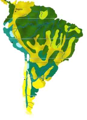
The area of the genus Gymnocalycium is interspersed with several gaps in its spreading. Representatives of this genus are in Bolivia, Paraquay, Brasil, Uruquay and Argentina. According to this gigantic region there are different climatic conditions for the various species.
The Gran Chaco is the main region of the Gymnos. The name Gran Chaco comes from the Quetschua language and means large hunting ground. The region covers an area in the southern middle of South America of approx. 647 500 km². It extends to north-east Argentina from east Bolivia, west Paraquay and reaches till Brasil. Part of the Chaco in Argentina are the provinces Formosa, Chaco and parts of the provinces Cordoba, Santiago Del Estero, Tucman and Salta. The climate in the east of the Chaco is subtropically with annual rainfalls up to 1800 mm that decreases from east to the west. The western part has tropical climate, rain up to 500 mm and little rainfall in the winter.
Single areas are often flooded by rivers in the rainy season in the summer (December to April). The ground mostly consists of clay and sand.
Reed and palms grow along the rivers in the east and there are dry wood and thorn bushes in the interior; dry, deserted areas lie in the west. There are 4 subgenuses of the genus Gymnocalycium in the Chaco. Gymnocalycium, Microsemineum, Trichomosemineum, Muscosemineum.
Parts of the Argentine provinces of La Roja, San Juan and Mendoza are described as Cuyo region. The surface is approx. 232.000 square kilometer. One distinguishes two subregions, the area of the Anden and the valleys in the east, geographically. The central of the Anden is dominated by dry climate. There are large changes of temperature between day and night.
Annual rainfall approx. 200 mm. The rivers in the dry plains are feeded by the Anden. Here dominates the Monte. A bush-forest located on half-desert ground is described as Monte. It looks more like bushes than like a forest.
A further habitat is the Pampa, a gigantic area in central Argentia (535.000s km ²) which rises from the atlantic coast up to the mountains of the Anden. The Pampa is limited by the Chaco in the north, by the Rio Parana in the north-east and by Patagonien in the south. The whole province of Buenos Aires, large parts of La Pampa Cordoba and Santa Fe belong to this area. One distinguishes two subregions, the east Pampa (damp Pampa - Pampa Humeda) and the west Pampa (dry Pampa - Pampa Seca).Pampa Humeda extends from the rivers Parana and Rio De La Plata till the south of San Luis. With exception to the mountain ranges of Tandil and La Ventana the area represents a fertile plain. The climate is moderate, rainfall is 500-1000 mm every year.
The Pampa Seca adjoins to Pampa Humeda in the west. There are only a few rivers, mostly temporary lagoons and saltslakes. The name Pampa comes from the Quecho-Indians and means flat surface, treeless ground. 60% of the cattle breeding and 90% of the agriculture are operated here. The very firm ground promotes the growth of grasses, the growth of trees is restricted for the same reason.
The Gymnocalycium G. gibbosum is the furthest in the south of Argentina. The distribution reaches till the eastern part of the province Chubut.
The habitat of the subgenus Macrosemineum extends from Brasil (southern Rio Grande De Sul) to Uruguay. Subtropic climate within all seasons and rainfalls prevail here. The winters are mild and the summers warm. Uruguay isn't more dominated by forests but by grasses today. The largest threat for the cacti of these areas is the cattle breeding.
|